

Billk - NM Trackplan
- Thread starter Tyson Rayles
- Start date
You are using an out of date browser. It may not display this or other websites correctly.
You should upgrade or use an alternative browser.
You should upgrade or use an alternative browser.
C
Catt
Thanks Tyson. Coupla questions, then you can get back to work.
The hidden staging - looks to be at a lower level, right? How much lower?
How (or do) you turn anything around?
Regards, Bill
The hidden staging - looks to be at a lower level, right? How much lower?
How (or do) you turn anything around?
Regards, Bill
trackplan
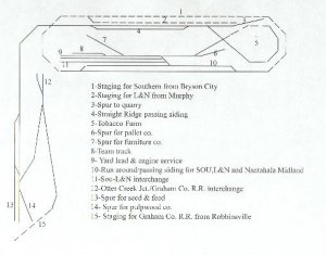
 Sorry guys, should have included more details. I will try to make up for that now. The town at the top is Tellico Gap and the center of operations for the Nantahala Midland. The town at the lower left is White Oak. The staging tracks for the Southern & L & N are at 44.5 inches, Tellico Gap 45 inches, Straight Ridge and the quarry spur 48 inches, White Oak 49.5 inches, Otter Creek Jct. 46.5 inches, Staging for the Graham Co. R.R. 45 inches. The track indicated by dotted lines is hidden in tunnels or behind scenery. All grades were made using Woodland Senics 4% grade kits. These are GREAT as you can put your grade on a straight, curve or compound curve without having to do all the math! On the real R.R.'s around here you have grades like Topton, Old Fort and Saluda all 4.25 to 5.2% so I am not out of line with the prototype. I would have liked to have used 2 or 3% but space wouldn't permit it. My time period is around 1970 so every thing is desiel and there is no need to turn anything, which is good because I didn't have room for space gobblers like turntables and wyes.Hope this helps explain things.
Sorry guys, should have included more details. I will try to make up for that now. The town at the top is Tellico Gap and the center of operations for the Nantahala Midland. The town at the lower left is White Oak. The staging tracks for the Southern & L & N are at 44.5 inches, Tellico Gap 45 inches, Straight Ridge and the quarry spur 48 inches, White Oak 49.5 inches, Otter Creek Jct. 46.5 inches, Staging for the Graham Co. R.R. 45 inches. The track indicated by dotted lines is hidden in tunnels or behind scenery. All grades were made using Woodland Senics 4% grade kits. These are GREAT as you can put your grade on a straight, curve or compound curve without having to do all the math! On the real R.R.'s around here you have grades like Topton, Old Fort and Saluda all 4.25 to 5.2% so I am not out of line with the prototype. I would have liked to have used 2 or 3% but space wouldn't permit it. My time period is around 1970 so every thing is desiel and there is no need to turn anything, which is good because I didn't have room for space gobblers like turntables and wyes.Hope this helps explain things.trackplan
Thanks Charlie, I like operation and with 3 live interchanges the fast clock really starts to be important. The con. loop isn't used in operation but is there for visitors.
Thanks Charlie, I like operation and with 3 live interchanges the fast clock really starts to be important. The con. loop isn't used in operation but is there for visitors.