All sorts of Bridges

K.V.Div

Member
May 10, 2001
625
0
16
68
Shawnigan Lake, B.C. Canada
Visit site
Last shot shows the tracks approaching the bridge.
The sign with the two black dots is a "Flanger Warning sign" which tells the operator of a flanger, spreader or a snowplow equipped with a flanger that there is an obstruction between the rails ahead (in this case, the bridge guardrails) and that the flanger blades must be raised to avoid damaging them.

Terry
 

Attachments

  • p4210004.jpg
    p4210004.jpg
    51.5 KB · Views: 258

K.V.Div

Member
May 10, 2001
625
0
16
68
Shawnigan Lake, B.C. Canada
Visit site
It may be a "teensie weensie" bridge Woodie, but like all bridges, it has it's purpose.
I'd give a weeks wages to see a train jump across that creek:eek:.
Actually, there over 50 such bridges on the E&N, as well as many more larger ones, some of them quite long and high.
I'll try to get out and get a few pics of the Arbutis Canyon trestle and Niagra Canyon cantilever bridge sometime soon. It just takes a little bit of mountain climbing and boonie bashing (hiking through the forest) to get up to them
:).
Cheers!

Terry
 

railohio

Active Member
Dec 29, 2000
999
0
36
Here's another bridge photo to keep ya goin'!

Amtrak201MagnoliaWV3-24-03Small.jpg
 

railohio

Active Member
Dec 29, 2000
999
0
36
I suppose some explanation is in order....

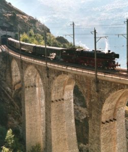
The first bridge is across the Potomac River at Magnolia, West Virginia. The bridge is a part of the "Magnolia Cutoff," a line relocation completed by the B&O in the early 1900s that removed the rail line from the flood prone river valley. The original right-of-way along the river, from which this photo was taken, is still used as an access road by CSX and is kept open to the public for access to area hunting grounds. In this shot, P030, Amtrak's eastbound Capitol Limited crosses the bridge on March 24, 2003. [Nikon N80, 24mm f/2.8 AF-D Nikkor, Fuji Provia 100F, exposure unrecorded.]

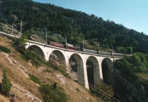
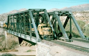
The second photo is of the Western Maryland Scenic's bridge over Braddock Run and Alt. U.S. 40 just west of Cumberland. The bridge is located in the "Cumberland Narrows," a valley which once held the tracks of the competing Western Maryland and B&O. After the Chessie merger of the 1970's the former Western Maryland line was deemed surplus and sold. The Western Maryland Scenic uses the line from Cumberland to Frostburg for their steam-powered excursion trains. Like all the other bridges on the WM's Connelsville Extension, this bridge was built to accomodate two tracks, although two tracks were never built across it. I shot this photo while waiting for the return of a WMS excursion on August 10, 2001. [Nikon FM-10, 35-70mm f/3.5-4.8 AIS Zoom-Nikkor, Agfa Scala 200X, exposure unrecorded.]
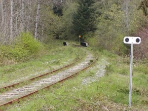
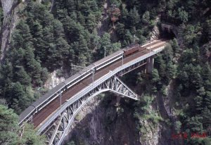
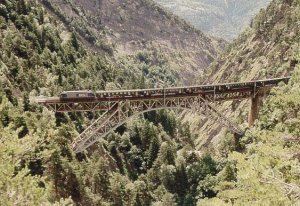
 

RailRon

Active Member
Nov 23, 2002
1,602
0
36
80
Trimbach, Switzerland
So the left track of the WMS bridge is exclusively reserved for ghost trains... :eek: :eek: :eek: :eek: :eek:

Seriously, this is a rare example of a through truss bridge with curved track on it. Because of the sideways pressure of a passing train they always tried to construct such bridges on a tangent piece of track. However this picture gives us modelers an fine excuse to build such a bridge in a curve. :)

Ron
 

RailRon

Active Member
Nov 23, 2002
1,602
0
36
80
Trimbach, Switzerland
This second pic shows a little more of the surroundings. It is a narrow side valley (the 'Bietschtal' - Tal (German) = valley) of the Rhone river valley in the Alps.

The tracks lead from a tunnel into a tunnel. When you are riding a train, you really don't have much time to enjoy the view from the bridge!

Ron
 

Attachments

  • bietschtalbrücke 03.jpg
    bietschtalbrücke 03.jpg
    98.6 KB · Views: 206

Matthyro

Will always be re-membered
Dec 28, 2000
4,550
0
36
86
Georgetown, Ontario,Canada
Some impressive bridges Brian and Ron. Thanks for the detailed information Brian.
Ron, where on earth did you have to go to get those pictures? You must be a mountaineer to get into position to get those great photos.
 

sumpter250

multiscale modelbuilder
Jan 19, 2002
3,073
0
36
80
Vernon Hills, Illinois
Visit site
Ron,
That first shot of the Bietschtal bridge clearly shows a couple of things. You can see that three separate, straight, spans are used to carry the curve across the valley. You can also see just how vertical the ground can get, and still have trees growing on it!
This is an excellent reference photo for mountainous scenery.
Pete
 

RailRon

Active Member
Nov 23, 2002
1,602
0
36
80
Trimbach, Switzerland
Robin, to be honest - it wasn't me who made those pics. :rolleyes:

The tracks belong to the railroad line between the South portal of the Loetschberg tunnel at 1200 meters (4000 ft), descending along the mountain side for 25 km (15.5 miles) to Brig at 700 m (2300 ft). The line is extremely spectacular with lots of tunnels and all sorts of bridges.

However, I have been at exactly these photo spots several times. There is a fairly tight net of beautiful hiking paths in these mountains - and it is even quite easy to make these tours. All you need are good trekking shoes, rain and sun protection, a picknick and (for such pics) a camera. The left photo inset shows, that the paths are easy for walking.

As the map shows, there is one path which follows more or less the railroad line - sometimes a little higher, sometimes a little lower. Of course you have to walk all around rock noses (can't walk through the tunnels :eek: ). On the right photo you see a small tunnel for that path below the left end of the bridge.

It is a hike of about 4 1/2 hours from Hohtenn (left) to Eggerberg, 5 hours to Lalden (right). There are special round tickets - you leave the train at Hohtenn and board it again at Eggerberg or Lalden. It's really a wonderful tour. When you visit Switzerland - try it!

Ron

(Reading all that, I think I probably should get a medal from the Swiss tourist office! :D :D :D )
 

Attachments

  • lötschbergsüdrampe2.jpg
    lötschbergsüdrampe2.jpg
    98.4 KB · Views: 179

RailRon

Active Member
Nov 23, 2002
1,602
0
36
80
Trimbach, Switzerland
Pete, you're right - 'curved' steel bridges always are built up from a series of straight elements.

On the other side, masonry viaducts can be curved. Here is a beautiful example of that species on the same BLS line - the 'Luogelkinn' viaduct. (Try to pronounce that in English!:D :D :D ) On the map above it is marked with the green dot.

If you look closely, you see that the the second loco is a steamer. It is a German 01 type which was restored by a group of enthusiasts here in Switzerland. The brown loco is an electric Ae 6/8 of the BLS (also an oldie) doing helper service.
 

Attachments

  • luogelkinn 1.jpg
    luogelkinn 1.jpg
    80.8 KB · Views: 321

RailRon

Active Member
Nov 23, 2002
1,602
0
36
80
Trimbach, Switzerland
On the same fan trip the steam loco made a solo appearance on the point of the train. This shot is also made from the hiking path.

Another interesting detail: The bridge originally was built single track. About 25 years ago, when the last sections of the line were double tracked, they broadened the whole viaduct on the valley side. In fact, the added part is poured concrete (visible in the round openings at the top), but the pillars were blended with simulated masonry stones. Looks great, doesn't it?

Ron
 

Attachments

  • luogelkinn 2a.jpg
    luogelkinn 2a.jpg
    77.9 KB · Views: 310

DanRaitz

Member
May 30, 2002
300
0
16
Maricopa, AZ, USA
Theres this bridge that crosses the Mojave River just east of Victorville, CA (on the east side of Cajon Pass).
 

Attachments

  • victorville.jpg
    victorville.jpg
    91.9 KB · Views: 264

Matthyro

Will always be re-membered
Dec 28, 2000
4,550
0
36
86
Georgetown, Ontario,Canada
Ron, thanks for the hiking path info and maps. I have done extensive hiking in the Rocky Mountains and would love the opportuntiy to come to Switzerland but my small pension budget won't allow it so will rely on your beautiful photos.